Nearby search is point-based. Riding is line-based.
That difference matters once you are tired, low on water, or trying to stay on a planned route. The nearest cafe might be behind you. The right one might be 18 km ahead, just before the long exposed section.
The best stop is not always the closest one. It is the place that solves the next real problem with the smallest real detour:
- Water before heat.
- Food before a long gap.
- Repair before remote roads.
- A station before the weather turns ugly.
Stop types that earn the detour
Different places reward different habits. In parts of Europe, public fountains and village taps can be excellent. In much of the US, gas stations are often the most dependable water, snack, and bathroom stop.
| Need | Good stop types | What to verify |
|---|---|---|
| Water | Drinking water, public taps, cemeteries, parks, cafes, gas stations. | Seasonal closure, potable signage, access, whether it is inside a building. |
| Food | Cafes, bakeries, supermarkets, convenience stores, gas stations. | Opening hours, Sunday closures, payment, rural gaps. |
| Mechanical help | Bike shops, repair stations, pumps, train stations. | Opening hours, pump type, whether tools are actually present. |
| Bailout | Train stations, bus stops, towns, hotels, shelters. | Bike rules, last train, weather shelter, mobile signal. |
Trust the map enough to investigate.
Public POI data is only as good as local mapping. OpenStreetMap can be excellent in one region and patchy in the next. For critical stops, treat the result as a lead, not a promise.
- Use street-level imagery or photos if available.
- Check opening hours for shops and cafes.
- Prefer clusters of options before long remote sections.
- Carry a backup if the next reliable water source is far away.
- When you find a missing or wrong place, update OpenStreetMap if you can.
For water, Route Companion keeps the search focused on drinking-water and public-tap style places, not random lakes, rivers, or generic water points.
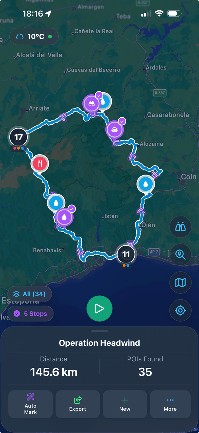
How Route Companion searches stops along a route
Route Companion imports or plans a route, searches a corridor around it, and orders matching places by where you will reach them. You choose the stop types and how far off-route you are willing to go.
Water, cafes, shops, gas stations, toilets, bike shops, repair stations, shelters, camping, pharmacies, ATMs, parking, hospitals, and train stations are checked in the context that matters: ahead, on-route, or worth the detour.
Marked stops can then go into Garmin, Wahoo, GPX, TCX, or FIT workflows instead of staying as mental notes you hope to remember.
What the app uses
Stop search is built on OpenStreetMap data. Route Companion searches a corridor around your route, filters by the stop types you selected, then orders results by where you will reach them.
For water, the search is focused on drinking-water and public-tap style mapping, not generic lakes, rivers, or every object tagged with water nearby.
Reference notes: coverage depends on local OpenStreetMap tagging. The most relevant tags for water include amenity=drinking_water, drinking_water, and man_made=water_tap.